Bank Street Gardens transform a confined part of the commercial centre into a public landscape, created through gifts of land, civic improvement and a design by Alfred T. Harrison.

Quick Facts
| Main Phases | Sandstone pillars at the Bank Street approach to the Mill Lade bridge erected in 1907; land acquired by the Burgh between 1939 and 1965; principal garden layout developed after the Second World War |
|---|---|
| Landscape Designer | Alfred T. Harrison, Superintendent of Parks, Edinburgh Corporation |
| Location | Between Bank Street and the Mill Lade, central Galashiels |
| Place Type | Municipal public garden and civic open space |
| Ownership | Galashiels Common Good asset GL040-05 |
| Designation | Not individually listed; within the Galashiels Conservation Area |
| Public Access | Scottish Borders Council records year-round access and seating |
| Official Town Trail | Stop 15 |
An Open Space in the Commercial Centre
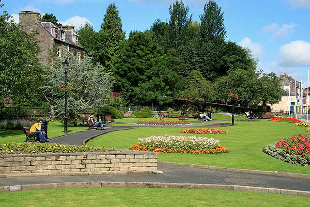
Bank Street Gardens are significant partly because they interrupt the otherwise close-built commercial fabric of central Galashiels. Lawns, paths and flower beds occupy ground behind the Bank Street frontage, while the surrounding buildings remain visible above and around the planting. The result is not an isolated park but a piece of designed townscape framed by the town centre.
Scottish Borders Council identifies the gardens as one of the important visual focal points within the Galashiels Conservation Area. Their value therefore lies in the relationship between landscape and buildings as much as in any individual planting scheme.
From Scott’s Place to Bank Street
Before it became Bank Street, the line of buildings was known as Scott’s Place. Robert Hall’s history of Galashiels associates its development with the diversion of an earlier road and building in ground known as Miller’s Park or the Swine. The name Bank Street came into use after the National Bank established premises there in 1825.
This earlier history matters because the gardens were inserted into an already developed commercial street. They were not the surviving grounds of a large house or an untouched fragment of countryside. Their creation required deliberate decisions to release private ground behind neighbouring properties and convert it into public open space.
The Bridge Entrance Pillars
The red sandstone pillars were erected in 1907 by public subscription to mark the Bank Street approach to the bridge over the Mill Lade. Their original function therefore belongs to the crossing and route over the lade, rather than to the later garden scheme.
As the gardens developed around this route, the pillars also came to form a formal threshold to the public space. Their substantial masonry gives the bridge approach a civic character and records public investment in improving the appearance and amenity of the town centre before the later transfers of garden land to the Burgh were complete.
Gifts of Land and Common Good
The Council’s Common Good Register gives the most precise available account of ownership. It records that the Burgh of Galashiels acquired the garden ground between 1939 and 1965. The land was gifted by proprietors of neighbouring buildings for a Council improvement scheme rather than obtained in one transaction.
The State Bank and the Liberal Club were among the early donors. Their conditions required the gifted ground to remain permanently in use as open space. Bank Street Gardens are consequently recorded as Galashiels Common Good asset GL040-05: property held for the benefit of the community rather than simply an ornamental area maintained at municipal discretion.
This staged history also explains why broad statements that the gardens were “gifted after the Second World War” need qualification. Much of their recognised civic form belongs to the post-war period, but acquisition began in 1939 and continued into the 1960s.
Alfred Harrison’s Design
Scottish Borders Council states that the gardens were laid out in conformity with proposals by Alfred T. Harrison, then Superintendent of Parks with Edinburgh Corporation. His involvement placed the scheme within a professional tradition of municipal landscape design: arranging paths, lawns, planting and circulation to make a constrained urban site both attractive and usable.
The present gardens are known for long, sweeping seasonal displays set within lawns. Planting changes over time, so individual beds should not automatically be attributed to Harrison. The more durable historical interest lies in the overall idea of an ordered public landscape occupying the ground behind Bank Street.
The Mill Lade
The Mill Lade passes along the rear of the gardens. It is easily overlooked when attention is drawn to flowers and lawns, yet it connects this civic space with the water-powered industrial system that shaped Galashiels.
Bank Street itself was laid out broadly parallel with the lade. The proximity of watercourse, commercial frontage and later public garden compresses several phases of the town’s development into a small area: industrial infrastructure, nineteenth-century urban growth and twentieth-century civic improvement.
Things to Notice
- The red sandstone pillars marking the Bank Street approach to the bridge over the Mill Lade.
- The way the gardens open a view through a densely built commercial street.
- The changing levels between Bank Street, the garden ground and the Mill Lade.
- The backs and upper storeys of neighbouring properties, which reveal how the open space was assembled behind an existing frontage.
- The relationship with the former Liberal Club and other Bank Street buildings associated with gifts of land.
- The Mill Lade at the rear, linking the gardens to the industrial history of the town.
Why It Matters Today
Bank Street Gardens demonstrate how private land, public subscription and municipal planning could combine to produce a lasting community asset. Their common-good status gives that story continuing legal and civic relevance.
They also provide something increasingly scarce in a town centre: an accessible place to pause while remaining visually connected with surrounding streets and buildings. Protecting the gardens means caring for their entrances, paths, planting, boundaries, watercourse and architectural setting as a connected whole.
Significance Scores
| Criterion | Score | Reason |
|---|---|---|
| Architectural and Landscape Interest | 3/5 | A professionally planned civic garden whose setting includes the distinctive sandstone pillars at the approach to the Mill Lade bridge. |
| Historical Importance | 4/5 | Records successive phases of town-centre development, public subscription and municipal improvement. |
| Social Significance | 5/5 | Land gifted for permanent public use and now recorded as a Galashiels Common Good asset. |
| Rarity | 3/5 | A notable surviving town-centre garden, although municipal gardens are not intrinsically rare. |
| Townscape Contribution | 5/5 | An important visual focus and open interval within the dense commercial centre. |
These are editorial guide scores, not statutory designations. See How We Assess Significance.
Timeline
- Early nineteenth century: Scott’s Place develops on the line later known as Bank Street.
- 1825: The National Bank establishes premises and the name Bank Street comes into use.
- 1907: The red sandstone pillars at the Bank Street approach to the Mill Lade bridge are erected by public subscription.
- 1939–1965: The Burgh acquires gifted parcels of land from neighbouring proprietors for a public improvement scheme.
- After the Second World War: The principal garden layout is developed in accordance with proposals by Alfred T. Harrison.
- Today: The gardens remain public open space and a Galashiels Common Good asset.
Notes and Uncertainties
- The 1907 bridge-approach pillars and the later garden layout are separate phases; the pillars were not originally designed as an entrance to the gardens.
- The Common Good Register records staged acquisition between 1939 and 1965, qualifying simplified accounts of a single post-war gift.
- The available online sources name Alfred T. Harrison and his office but do not provide a dated surviving plan or define precisely which present details follow his proposals.
- Seasonal planting is renewed and should not be assumed to reproduce the original post-war scheme.
- The extent to which the Mill Lade is presently visible from within the gardens may vary with access, vegetation and maintenance.
Image and Licence Notes
The 2007 photograph by Walter Baxter is reused from Geograph through Wikimedia Commons under the Creative Commons Attribution-ShareAlike 2.0 Generic licence. No alterations have been made.
Related Places
- Bank Street Listed Buildings Group
- Former Galashiels Liberal Club, 42 Bank Street
- Gala Mill Lade and Round Tree Bridge
- Burgh Chambers and Clock Tower
- Sir Walter Scott Monument, Cornmill Square
Sources
- Scottish Borders Council, Galashiels Common Good Register.
- Scottish Borders Council, Bank Street Gardens parks and gardens record.
- Scottish Borders Council, Galashiels Conservation Area.
- Historic Scotland, Historic Galashiels: Archaeology and Development.
- Robert Hall, The History of Galashiels (1898), p. 99.
- Official Galashiels Town Trail, Stop 15: Bank Street Gardens.
- Wikimedia Commons file and licence record for Walter Baxter’s photograph.
Last reviewed: 24 July 2026.