One of the oldest and most architecturally layered surviving buildings in Galashiels, Old Gala House provides a remarkable link between the town’s early settlement, its landed estate and its later civic identity.

Quick Facts
| Location | Scott Crescent, Galashiels |
|---|---|
| Listing status | Category A listed building, LB31973 |
| Earliest visible phase | Bastle or fortified laird’s house dated 1583 |
| Main later phases | 1611, about 1632-35, about 1830 and 1859-60 |
| Historic families | The Hoppringill or Pringle family, followed by the Scotts of Gala |
| Historic setting | Formerly the principal house within extensive policies on the western side of the Old Town |
| Later uses | Galashiels Arts Club from 1949; acquired for the burgh in 1975; converted as a museum in 1988 |
| Current role | Museum, gallery, community venue and Common Good property operated by Live Borders |
| Coordinates | 55.61400, -2.80861 |
A House Built Over Centuries
Old Gala House was not conceived as a single architectural composition. It grew in stages as the needs, security and status of its owners changed. Historic Environment Scotland identifies the earliest visible fabric as a two- or three-storey bastle built in 1583 by Andrew Hoppringill, or Pringle. A bastle was a strongly built residence designed to offer a degree of protection in a region where raiding and insecurity had long shaped domestic architecture.
The site itself may be older. Documentary and antiquarian sources refer to a tower here from 1457, still standing in 1544, but HES is careful to state that this structure is no longer separately evident. It may lie beneath or have been absorbed into later work. The distinction matters: 1457 belongs to the history of the site, while 1583 is the earliest confidently identified standing phase.
In 1611 a substantial perpendicular range, including a prominent stair tower, was added to the south-east. A further range of about 1632-35 helped create the irregular U-shaped plan. The building was enlarged and remodelled again in the 18th and 19th centuries. Projecting gabled bays added about 1830 gave greater unity to the garden and entrance elevations, while builders Robert Hall and Company carried out documented additions and alterations in 1859-60.
This accumulation is one of the house’s greatest strengths. Rubble masonry, differently treated sandstone dressings, altered openings, towers, gables and chimney stacks reveal that Old Gala House was repeatedly adapted rather than frozen in one period. It is best read as a physical record of changing domestic life extending over more than four centuries.
The Pringles, the Scotts and the Lairdship of Gala
The house was originally associated with the Hoppringills, more commonly known as the Pringles. HES records that Andrew Pringle made Galashiels his principal residence in 1611. In the 1630s, Jean Pringle married Hugh Scott, and the Scotts subsequently became the lairds of Gala. The change of family is recorded unusually vividly inside the building.
A richly painted timber ceiling, dated to about 1635 and rediscovered in 1952, is associated with the Pringle-Scott marriage and the remodelling of the house. Its polychrome geometric and arabesque decoration is among the building’s most important surviving interiors. Later rooms contain equally revealing work, including 19th-century decorative plaster ceilings. HES describes imagery of Persephone and the four ages of a woman in the drawing room, while the staircase and hall include the plum tree and fox, long-established symbols of Galashiels.
These interiors connect family history with local identity. Old Gala House was the residence of landowners whose decisions affected roads, housing, gardens and the direction in which the settlement could grow. It was not simply a private house beside Galashiels: for much of its history it was one of the principal organising features of the place.
The House, Its Policies and the Early Settlement
Historic Environment Scotland notes that Old Gala House originally stood within its own policies to the west of the Old Town. In Scots usage, the policies were the enclosed and managed grounds belonging to a country house: gardens, parkland, woods, drives, service areas and productive ground as well as ornamental landscape. The policies associated with Gala House were extensive enough to influence the shape of the settlement around them.
The Historic Scotland burgh survey explains that by the late 18th century Galashiels was beginning to grow away from the bounds of Gala House. An estate map of 1795 shows development spreading along the lower routes beside the Gala Water. It also records a significant act of estate planning: the road north from the old cross was closed and the northern part of the older settlement was absorbed into the parkland of Gala House. The laird’s landscape could therefore expand at the expense of part of the earlier village, while new development was directed towards the valley floor.
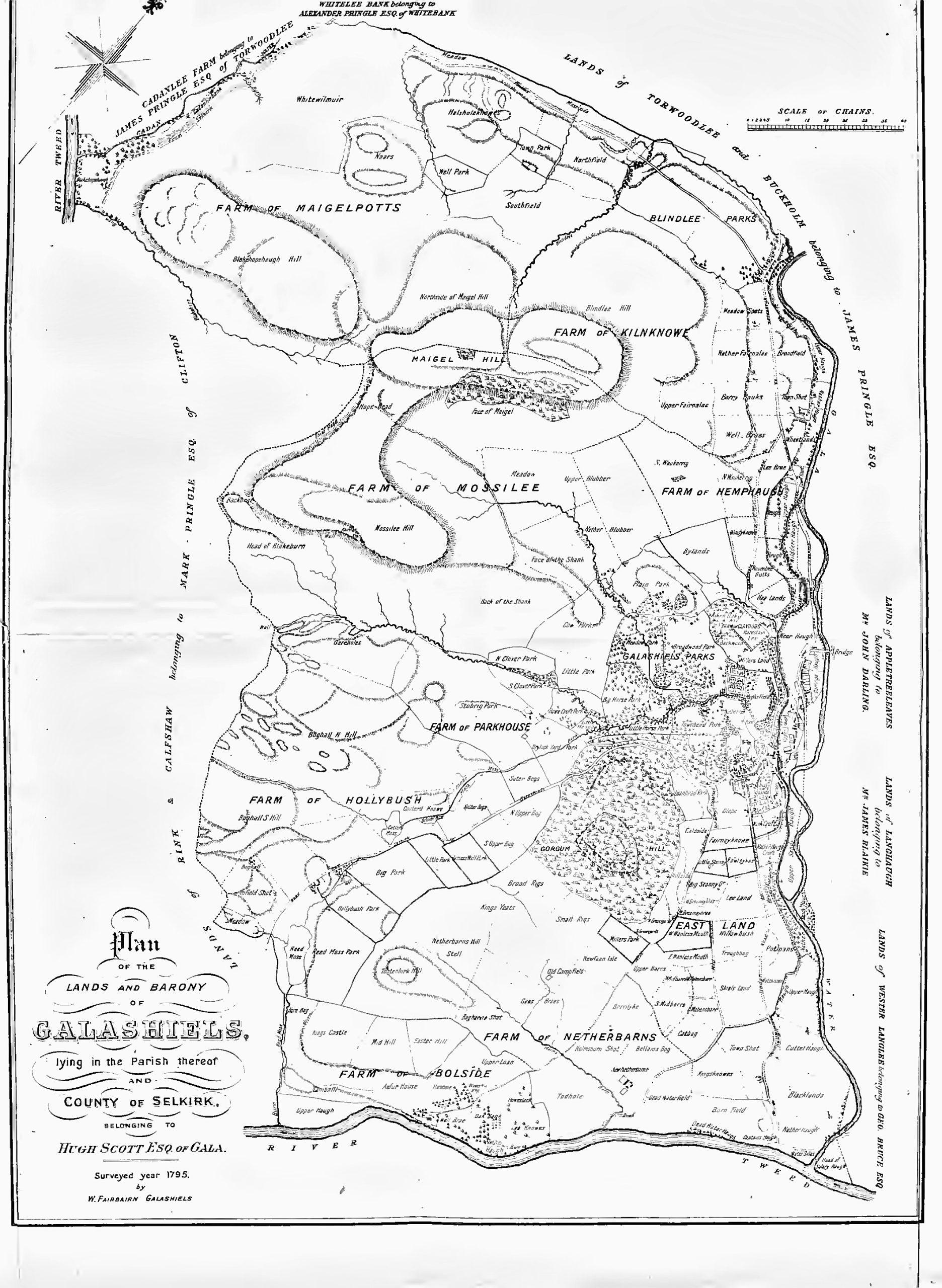
This helps explain the later geography of Galashiels. The Old Town remained close to the house, churchyard and cross, but the commercial and industrial centre increasingly developed along the roads and watercourses to the east and north-east. As mills, workshops, shops and housing multiplied, the settlement gradually wrapped itself around what had once been a comparatively detached laird’s residence.
What Wood’s 1824 Plan Reveals
John Wood’s Plan of Galashiels, surveyed in 1824, is especially useful because it maps both the town and the Gala estate at a large scale. The National Records of Scotland catalogue describes a plan showing named streets, buildings in block plan, occupiers of land and houses, and a reference table identifying important premises.
Wood’s plan captures Galashiels before the most dramatic Victorian industrial expansion. Old Gala House can be understood in relation to the compact older settlement, while the estate ground around it still occupies a conspicuous area. The plan makes the contrast legible: close-grained buildings and routes associated with the town sit beside the more open, controlled landscape of the laird’s policies. It is a visual explanation of why the house now feels embedded within Galashiels even though it originally stood in a much broader estate setting.
The map should not be treated as a perfect photograph of every boundary or building use, but it is strong evidence for spatial relationships at a particular moment. Visitors can examine the National Records of Scotland catalogue entry for Wood’s 1824 plan and a National Library of Scotland online copy of Wood’s 1824 plan.
How the Estate Landscape Was Developed
Only fragments of the older policies can now be read as a connected landscape, but HES identifies several important survivals and later uses. The present Galashiels Bowling Club green was a decorative rose garden in the mid-19th century. A very large walled garden occupied ground later developed for St Margaret’s RC Primary School on Livingston Place. Woodnook and Bellendean on Gala Terrace, although altered and now in separate ownership, originated as kennels associated with the estate.
Road building, housing and public institutions progressively divided the setting. Scott Crescent and neighbouring streets brought the expanding town close to the house. In 1872 Hugh Scott commissioned David Bryce to build New Gala House farther west, accompanied by a new designed landscape. Old Gala House ceased to be the family’s principal residence, and the focus of the Gala estate shifted into what became the New Gala House policies.
The old and new policies are related but should not be confused. The older grounds around Old Gala House were increasingly absorbed by urban development, gardens, schools and recreation. The more westerly landscape around New Gala House later became Scott Park and the surviving Gala Policies. Together, their history shows how land once controlled as a private estate was gradually converted to housing, education, recreation and public open space.
From Private Residence to Civic Landmark
By the end of the 19th century the building had entered a new phase and appears as “Beechwood” on the 1897 Ordnance Survey map. It became the home of Galashiels Arts Club in 1949. Scottish Borders Council’s Common Good register records that the property was acquired for the burgh in 1975 under an agreement that continued to provide premises for the Arts Club.
In 1988 Page and Park Architects refurbished the interior for museum and office use. The museum brought together the history of the house and the town, including civic objects such as the original shaft of the Mercat Cross and material from the demolished Old Tolbooth. Old Gala House is now operated by Live Borders as a museum, gallery and events venue. Its collections and exhibitions allow the building to interpret the settlement that eventually grew around it.
The survival of Old Gala House is particularly poignant because New Gala House, built to supersede it, was demolished in the later 1980s. The supposedly obsolete residence outlived its Victorian replacement and found a durable public purpose. It is now held as a Galashiels Common Good asset, giving its long association with the town a formal civic expression.
Things to Notice
- The irregular U-shaped plan, which reveals several distinct building campaigns
- The 1611 stair tower rising above the rear courtyard
- The mixture of rubble masonry, sandstone quoins and differently treated window surrounds
- The projecting 19th-century gables, crenellated details and varied chimney stacks
- The formal garden elevation and the way the ground rises to the east
- The surviving boundary walls and their relationship with Scott Crescent and the bowling green
- Inside, where accessible, the painted timber ceiling and later decorative plasterwork
- The contrast between the confined modern setting and the extensive estate landscape recorded on early maps
Timeline
- 1457: A tower is recorded on the site, although no separate standing fabric has been securely identified.
- 1583: Andrew Hoppringill or Pringle builds the earliest clearly surviving bastle phase.
- 1611: A substantial range and stair tower are added as Pringle makes Galashiels his principal residence.
- About 1632-35: Further additions help form the U-plan; Jean Pringle’s marriage to Hugh Scott is associated with the painted ceiling.
- 1795: Estate mapping records the house, policies and changing relationship with the settlement.
- 1824: John Wood surveys his detailed plan of Galashiels and the Gala estate.
- About 1830: Projecting gabled bays reshape and unify the exterior.
- 1859-60: Robert Hall and Company undertake additions and alterations.
- 1872: New Gala House is commissioned and Old Gala House ceases to be the principal estate residence.
- 1949: Galashiels Arts Club begins using the house.
- 1952: The 17th-century painted ceiling is rediscovered.
- 1971: Old Gala House is designated a Category A listed building.
- 1975: The property is acquired for the burgh.
- 1988: Page and Park complete its conversion for museum and public uses.
Why It Matters
Old Gala House is important not simply because it is old, but because its architecture and setting explain how Galashiels changed. It preserves the fortified character of an early laird’s house, the ambitions of later estate owners, the memory of extensive policies and the point at which a landed settlement became an industrial town. Its rooms contain unusually rich decoration, while its surviving surroundings retain fragments of gardens and estate functions that can still be traced through maps and records.
It also demonstrates the value of continued use. Adaptation by the Arts Club, the burgh and the museum service allowed the building to remain part of daily civic life. Old Gala House is both evidence of former hierarchy and a place now used to tell the shared history of the wider community.
Significance Scores
These are editorial guide scores for public interpretation, not statutory designations.
| Criterion | Score | Reason |
|---|---|---|
| Architectural Interest | 5/5 | Reflects the quality and distinctiveness described in this entry. |
| Historical Importance | 5/5 | Records an important part of Galashiels’ development. |
| Social Significance | 5/5 | Represents the people, work or community life associated with the place. |
| Rarity | 5/5 | Assesses the survival and scarcity of this building type or evidence. |
| Townscape / Landscape Contribution | 5/5 | Contributes to the character and legibility of its setting. |
See the significance scoring methodology.
Notes and Uncertainties
- The 1457 tower: This is part of the documented site history, but HES does not identify it as separately visible standing fabric.
- Seventeenth-century chronology: Sources use dates around 1632 and 1635 for the south-west range, marriage and remodelling. The sequence is clearer than the precise completion date of every element.
- Robert Hall or Mall: The HES listing names Robert Hall and Company for the circa 1860 work; one Trove transcription appears as “Robert Mall”, probably reflecting the underlying archival wording or a transcription issue. The HES form is used here.
- Wood’s plan: The map is evidence for layout and spatial relationships in 1824. Statements about the social meaning of open estate ground beside close-grained settlement are interpretation and should be read as such.
- Current access: The museum operates seasonally. Visitors should consult Live Borders for current opening dates and access information.
Related Places
- Gala Aisle and Old Churchyard
- Scott Crescent Heritage Group
- New Gala House
- Old Parish and St Paul’s Church, Scott Crescent
- Burgh Chambers and Clock Tower
Sources
- Historic Environment Scotland, LB31973: Old Gala House Including Boundary Walls – statutory designation and detailed architectural account.
- Trove, “Galashiels, Scott Crescent, Old Gala House” – NRHE record, archival references and historic images.
- Historic Galashiels: Archaeology and Development – Historic Scotland’s burgh survey, including early estate maps and analysis of settlement growth.
- Robert Hall, The History of Galashiels (1898), map facing p. 76 – printed reproduction of William Fairbairn’s 1795 estate plan.
- National Records of Scotland, RHP140068: Plan of Galashiels, 1795 – catalogue record for Fairbairn’s original estate plan.
- National Records of Scotland, RHP82832: John Wood’s Plan of Galashiels and the Gala Estate, 1824.
- Scottish Borders Council, Galashiels Common Good Register – civic ownership and present asset status.
- Live Borders, Old Gala House – current museum role and visitor information.
- RCAHMS, An Inventory of the Ancient and Historical Monuments of Selkirkshire (1957), no. 20, pp. 41-43.
- Kitty Cruft, John Dunbar and Richard Fawcett, The Buildings of Scotland: Borders (2006), p. 303.
Image and Licence Notes
Image: Iain Lees, Old Gala House, licensed under CC BY-SA 2.0, via Wikimedia Commons / Geograph. Original source: Geograph photo 765733.
Map: William Fairbairn, Plan of the Lands and Barony of Galashiels (surveyed 1795), reproduced from Robert Hall, The History of Galashiels (1898), facing p. 76. Hall’s printed reproduction is in the public domain. The website image has been converted to greyscale and its contrast and paper tone adjusted for legibility; no cartographic content has been added or removed. This is not a reproduction of the National Records of Scotland’s modern digital image of the original plan.