About 1882 · Barr Road · Category C listed
A substantial former parish manse whose house, stables, courtyard, boundary structures and hillside setting preserve an unusually complete picture of the domestic world attached to a major Victorian congregation.
Quick Facts
| Date / main phase | About 1882 |
|---|---|
| Location | Barr Road, Galashiels |
| Building type | Former parish manse with stables, courtyard and garden |
| Designation | Category C listed, LB50672 |
| Historic association | Built as the manse for St Paul’s Church |
| Public access | Private property; view only from public routes |
Why It Matters
The Old Parish Manse explains an aspect of church history that is easily missed when attention is confined to church buildings. A Victorian parish minister occupied a conspicuous public position, and the size of this house, its service buildings and its grounds express that status. The group is important not simply as a large villa, but as part of the institutional landscape created around St Paul’s Church.
Its interest is strengthened by survival beyond the main house. Former stables, the courtyard, boundary walls, gates and a watering trough retain evidence of how a substantial manse functioned. The steep garden and historic route known as Minister’s Walk connect the property spatially with Tea Street and the earlier parish centre.
The Story
Historic Environment Scotland dates the manse to about 1882, shortly after St Paul’s Church opened in Scott Crescent in 1881. The timing places it within the reorganisation of parish life that accompanied the rapid growth of nineteenth-century Galashiels. The new church and its manse gave the expanding town a suitably prominent ecclesiastical group while retaining a physical connection to the older parish landscape.
The house is two storeys high and is given character by a strong composition of gables and chimney stacks. Its stone elevations are comparatively restrained: the effect depends more upon massing, roofline and setting than upon elaborate ornament. This distinction is useful. The manse was intended to convey dignity and permanence, but it was a residence rather than a place of worship.
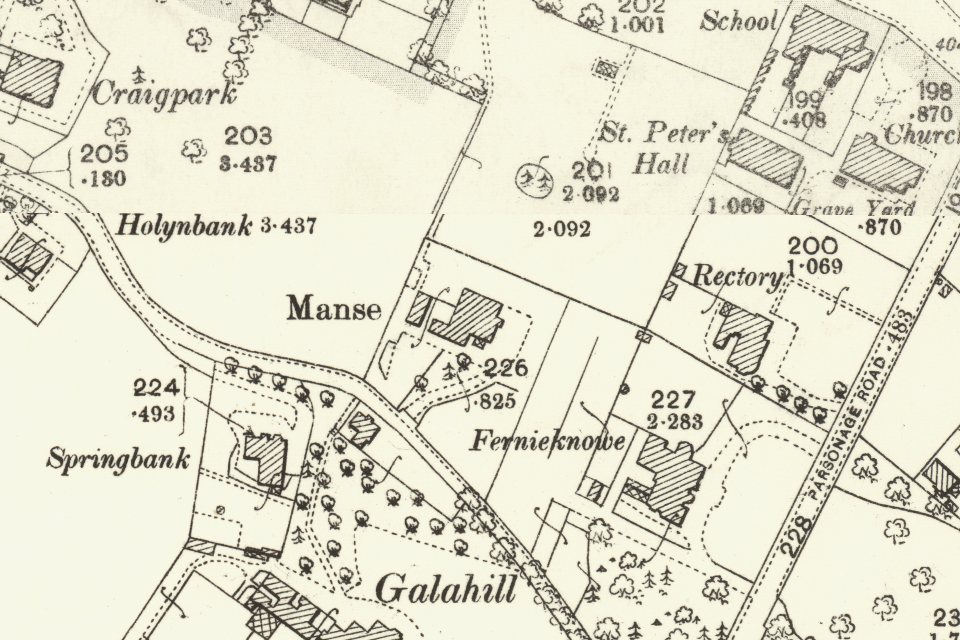
The associated service buildings make the site especially informative. Stables arranged around a courtyard, together with walls, gates and a trough, record the practical needs of a late nineteenth-century minister’s household. The historical map also shows that the manse stood within generous grounds on the edge of the built-up town. Later development has changed that wider setting, making the surviving garden and boundaries more valuable as evidence.
Minister’s Walk formerly led from the north boundary down towards Tea Street and the site of the Old Parish Church. That route helps to explain the manse as one point in a connected ecclesiastical landscape rather than an isolated house on Barr Road.
Things to Notice
- The multi-gabled roofline and prominent chimney stacks
- The contrast between the restrained stone elevations and the complex silhouette
- The enclosed former stable courtyard
- The boundary walls, gatepiers and watering trough
- The steep hillside setting and the historic line of Minister’s Walk
Significance Scores
These are editorial guide scores for public interpretation, not statutory designations. See how the significance scores are assessed.
| Criterion | Score | Reason |
|---|---|---|
| Architectural Interest | 4/5 | A substantial and coherent late Victorian manse group |
| Historical Importance | 4/5 | Closely connected with St Paul’s and the changing geography of parish life |
| Social Significance | 3/5 | Reflects the former public role and status of the parish minister |
| Rarity | 4/5 | Unusually complete with stables, courtyard, boundaries and historic route |
| Townscape / Landscape Contribution | 4/5 | Occupies a strong elevated position on Barr Road |
Uncertainties and Research Notes
- The date of about 1882 follows the HES designation record.
- The historical map documents the late nineteenth-century site and setting; it is not evidence of the present condition of the buildings or grounds.
- The property is private. A current architectural photograph should be taken only from a public route and without intruding upon residents.
Image and Licence Notes
The map extract is a static crop from an Ordnance Survey sheet made available by the National Library of Scotland under its stated CC-BY (NLS) reuse terms. It records the site’s historic form and setting, not its present architectural appearance. A suitably licensed present-day photograph can be added later.
Related Places
- Old Parish and St Paul’s Church, Scott Crescent
- Scott Crescent Heritage Group
- Tea Street Workers’ Housing
- Gala Aisle and Old Churchyard
Sources
- Historic Environment Scotland, Old Parish Manse, Barr Road, LB50672.
- Ordnance Survey, Selkirkshire Sheet VIII.NW & NE, surveyed 1897 and published 1900, National Library of Scotland.