Long-established mill site · acquired by the burgh in 1903 · removed during the creation of Cornmill Square
The lost mill that gave Cornmill Square its name, linking Galashiels’ early water-powered economy with the later creation of one of its most distinctive civic spaces.
Last reviewed: 26 July 2026
Quick Facts
| Date / main phases | A corn-milling tradition is associated with the area by the seventeenth century; the later mill was acquired by the burgh in 1903 and removed during redevelopment variously dated 1909-12 |
|---|---|
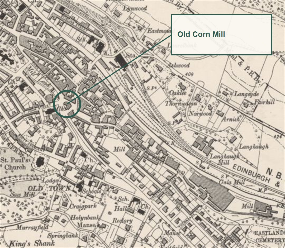
| Location | South end of Bank Street, on the site of present Cornmill Square |
| Site type | Lost water-powered corn mill and associated pond or lade system; later civic square and fountain |
| Designer of later square | Robert Lorimer is associated with the civic landscaping and fountain setting |
| Survival | Mill demolished; the name Cornmill Square and the altered watercourse preserve its memory |
| Public access | Public civic space |
Why It Matters
The Old Corn Mill is fundamental to understanding the landscape beneath the modern town centre. Before Galashiels became famous for woollen manufacture, grain had to be ground and water power was already being organised through burns, ponds and channels. The mill belonged to that older productive landscape.
Its removal also tells a second story. In the early twentieth century the burgh converted a workaday industrial site into a designed civic space. Cornmill Square therefore embodies a deliberate transition from production to public amenity, while retaining the old use in its name.
The Story
RCAHMS records that the corn mill formerly stood at the south end of Bank Street and was supplied by the Bakehouse and Mossilee burns. The wider water system may relate to artificial ponds associated with Sir James Pringle in the early seventeenth century. A 1795 estate plan shows a large pond, confirming that water storage and control were substantial features of the pre-industrial town.
The precise genealogy of buildings on the site is not yet fully reconstructed. References to corn mills in 1629 demonstrate an early tradition, but they do not prove that the structure eventually demolished was itself seventeenth century. Mills were rebuilt, enlarged and re-equipped while retaining an old site and name.
Historic Environment Scotland records that the town council purchased the corn mill in 1903. A National Records of Scotland plan, RHP82842, documents the Bank Street mill site in August that year. These records mark the beginning of the site’s transition into public ownership and a new civic purpose.
Sources disagree over the exact date of removal. RCAHMS, Trove and the Old Gala Club timeline give 1909, while the official Town Trail account places the removal in 1912. This may reflect different stages in demolition, clearance and completion of the square, but that explanation remains to be demonstrated. What is secure is that the mill disappeared during the remaking of the area in the first decades of the twentieth century.
The new setting, associated with Robert Lorimer, retained an open relationship with water through the fountain and the last exposed section of the lade. In this way the civic design did not wholly erase the site’s water-powered past. The name Cornmill Square completes that continuity.
Things to Notice at the Site
- The square’s name, which preserves the lost building more clearly than any surviving wall.
- The relationship between Bank Street, the lower ground and the controlled watercourse.
- The fountain and landscaped civic composition that replaced the mill environment.
- How the site forms a visual focus where several historic streets converge.
- The contrast between the present ornamental use of water and its former productive role.
Why Its Loss Matters
The loss of the mill removed direct architectural evidence for one of Galashiels’ oldest economic activities. Its footprint, machinery and relationship with the burns could have shown how grain milling worked before the town’s textile expansion. Yet the redevelopment is itself historically important. Cornmill Square demonstrates how an industrial burgh sought to create beauty, order and civic identity from an obsolete working site.
Significance Scores
| Criterion | Score | Reason |
|---|---|---|
| Architectural interest | 2 / 5 | The mill’s final architectural form is poorly documented and no building fabric survives. |
| Historical importance | 5 / 5 | The site links early water management and food production with the later civic remaking of the centre. |
| Social significance | 4 / 5 | Corn milling served an essential everyday need, while the replacement square became a shared public space. |
| Rarity | 3 / 5 | The building is lost, but the named site and surviving documentary record are unusually legible. |
| Townscape legacy | 5 / 5 | Its removal directly enabled the formation of Cornmill Square, a principal town-centre focus. |
Scores follow the published significance-scoring methodology. They are interpretive judgements, not statutory designations.
Timeline
- 1629 – documentary tradition associates Sir James Pringle with two corn mills and artificial ponds.
- 1795 – an estate plan depicts a large pond within the water-management landscape.
- August 1903 – the mill site is surveyed as the burgh acquires the property.
- 1909-12 – the mill is removed; surviving sources differ over the exact year.
- Early twentieth century – Cornmill Square and its fountain setting are created, associated with Robert Lorimer.
Notes and Uncertainties
The record of corn milling in 1629 establishes early activity but not the age of the final building. The demolition date is unresolved: 1909 appears in RCAHMS, Trove and Old Gala Club material, while the Town Trail gives 1912. The form and sequence of the mill buildings require further work using RHP82842, valuation rolls, newspapers and historic photographs. The later Green Street corn mill or granary should not be confused with this Bank Street site.
Image and Licence Notes
No image of the demolished mill is reproduced because a securely identified view with verified reuse permission has not been confirmed. Modern photographs of the fountain illustrate the replacement civic space, not the lost mill. The National Records of Scotland site plan is cited as evidence but has not been reproduced without a separate rights check.
Related Places
- Sir Walter Scott Monument, Cornmill Square
- Gala Mill Lade and Round Tree Bridge
- Waulkmillhead Mill, Bank Street
- Bank Street Gardens
Sources
- RCAHMS, Historic Galashiels: Archaeology and Development – mill location, water supply and 1909 removal date.
- Historic Environment Scotland designation LB31981 – burgh acquisition in 1903 and context for the later fountain.
- Trove, Galashiels, Cornmill Square, The Fountain – site history and surviving water feature.
- National Records of Scotland place catalogue for Galashiels – RHP82842, plan of the Bank Street corn-mill site, 1903.
- Official Galashiels Town Trail, Cornmill Square – local visitor account giving 1912 as the removal date.
- Old Gala Club timeline – local chronology of the mill’s removal and later Green Street mill.